salakhalimunmountain.com – Navigating the vast, undulating wilderness of Mount Halimun Salak National Park offers a true backcountry adventure through one of Java’s largest remaining primary rainforests. For much of a trek, the dense, multi-tiered canopy encapsulates you in a world of green shadows. But as your trail climbs out of deep drainage valleys and reaches high ridge shoulders, wind-swept saddles, or rocky sub-peaks, the canopy opens to reveal breathtaking panoramic vistas across the West Java volcanic highlands. Learning the art of triangulating position using Halimun peak views turns these fleeting visual openings into pinpoint navigational fixes, ensuring you maintain absolute spatial confidence across deep wilderness interiors.
Visual triangulation—also known in classical land navigation as resection—is a fundamental map-and-compass technique used by wilderness explorers for centuries. When dense foliage hides ground-level landmarks, sighting two or more prominent, known mountain peaks through a canopy break allows you to plot intersecting lines of position on a topographic map. The point where those bearing lines cross marks your exact position on the earth. In the sprawling Halimun-Salak corridor, where GPS signals can drift under wet canopy cover, mastering peak triangulation provides an unshakeable, self-reliant navigation anchor.
Understanding the Mechanics of Visual Resection
The core principle behind triangulating your position is simple geometry. If you take a magnetic compass bearing to a distinct, recognizable landmark—such as the distant pyramid of Mount Halimun’s main peak—you know that you are standing somewhere along a straight line projecting backward from that peak along the reciprocal bearing. A single bearing gives you a line of position, but it cannot tell you where you are located along that line.
To pinpoint your exact location along that single line, you need a second line of position that intersects it at a sharp angle. By taking a bearing to a second distinct peak—such as the jagged crater rim of Mount Salak or the distant dome of Mount Gede-Pangrango—and plotting its line of position on your map, your location is revealed precisely where the two lines cross. Adding a third peak sightline creates a small error triangle, providing ultimate verification of your position.
Selecting Prominent Visual Anchors in the Halimun-Salak Complex
Successful triangulation relies entirely on correctly identifying distant peaks through canopy openings. Halimun Salak National Park is anchored by several distinct high-elevation landforms that serve as excellent visual reference points when standing on elevated ridges.
To the west sits the expansive, heavily forested mass of Mount Halimun (1,929 m), characterized by its rolling, high-plateau ridgeline and sharp sub-peaks. To the east stands the iconic, highly eroded volcanic mass of Mount Salak (2,211 m), easily recognized by its sharp, notched crater rim and steep, radial ridges. On clear mornings, looking further southeast reveals the massive, twin-peaked volcanic silhouettes of Mount Gede and Mount Pangrango. Recognizing the unique profiles of these major peaks gives you reliable visual targets whenever a canopy gap opens.
Step-by-Step Triangulation Protocol on Ridge Vantage Points
When you reach an open ridge clearing or a rocky viewpoint where prominent peaks are visible, execute a disciplined step-by-step triangulation protocol to convert what you see into a precise map coordinate.
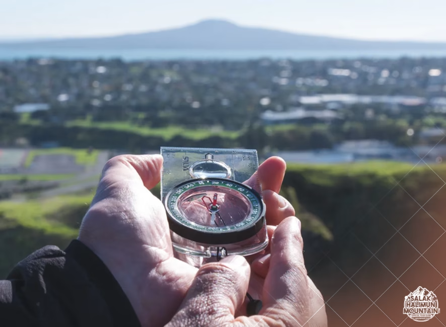
First, identify your chosen peaks with 100% certainty before taking sightlines. Hold your sighting compass at eye level, align the sighting wire or mirror with the center of the first peak’s summit, and rotate the bezel until the compass needle aligns with the orienting arrow. Read the magnetic azimuth directly off the index line. Repeat this exact process for a second peak, ensuring the angle between the two peaks is as close to 60 to 90 degrees as possible to maximize geometric precision.
Converting Magnetic Bearings to Grid Lines on a Topographic Map
Before plotting your observed bearings onto a paper topographic map, you must account for magnetic declination—the difference between magnetic north (where your compass needle points) and grid north on your map. In West Java, magnetic declination is relatively small, but failing to adjust for it can shift your plotted line by hundreds of meters across long distances.
Once your bearings are adjusted, calculate the reciprocal bearing for each peak by adding or subtracting 180 degrees (add 180° if the bearing is less than 180°; subtract 180° if it is greater). Orient your topographic map to north, place the corner edge of your baseplate compass on the mapped symbol of the first peak, and rotate the entire compass body until the orienting lines align with the map’s grid lines. Draw a light pencil line extending backward along the reciprocal bearing. Repeat for the second peak. The intersection of these lines marks your physical location.
Overcoming Tropical Navigational Challenges
In high-altitude tropical rainforests like Halimun Salak, executing visual triangulation presents unique challenges that require tactical adaptations. High atmospheric humidity and rapid tropical cloud formation often obscure distant views within minutes, offering only brief windows to take sightlines.
Clouds rolling up from lowland valleys frequently cap high mountain summits, leaving only lower ridge shoulders or sub-peaks visible. When main summits are obscured by cloud cover, use distinct, lower-elevation topographic features as secondary sightlines, such as prominent river gorge mouths, isolated volcanic knolls, or major saddle notches between ridges. These micro-features plot just as accurately on a detailed topographic map as high mountain peaks.
Handling Fleeting Canopy Openings
When a cloud gap opens for only a few seconds, you may not have time to execute a full map plotting procedure on the spot. In these situations, speed and mental accuracy are paramount.
Keep a small, waterproof notebook and pencil accessible in your chest pocket. The moment a distant peak breaks through the mist, shoot a quick magnetic bearing immediately and write down the exact bearing along with the time and peak name. Once you have written down two or three sightline bearings, you can step back under the shelter of the canopy, pull out your map, and comfortably perform your calculations and plotting out of the rain or wind.
Cross-Referencing Triangulation with Altimeter Contour Lines
Visual triangulation is even more powerful when combined with a barometric altimeter. An altimeter provides your exact vertical elevation above sea level, effectively giving you an invisible horizontal plane across the mountain landscape.
If cloud cover permits taking only a single reliable peak bearing, you can combine that single line of position with your altimeter reading. Locate the contour line on your map corresponding to your current altimeter elevation. Where your single reciprocal bearing line intersects that specific elevation contour line is your exact location. This hybrid method—combining one visual bearing with barometric elevation—is an invaluable backup technique when partial cloud cover blocks secondary peak views.
Building Deep Wilderness Self-Reliance in Java’s Highlands
Relying on physical map-and-compass skills like peak triangulation elevates your sense of competence and connection to the landscape. While digital navigation apps are convenient tools, screens can fail, freeze in heavy rain, or run out of battery in cold high-altitude environments. Knowing how to read the landscape with your own eyes and plot your position manually ensures you are never truly lost.
By observing the surrounding mountain architecture, identifying major volcanic peaks, and practicing sightline geometry whenever a canopy gap appears, you master the timeless art of wilderness navigation. Navigating the high ridges of Mount Halimun and Mount Salak with spatial mastery allows you to explore Java’s wild heart with total confidence and profound respect for the living mountain terrain.
So, if you’re ready to explore the wonders of Mount Salak Halimun, head over to our ONLINE BOOKING PAGE and let’s start planning your adventure. Or simply CLICK THIS LINK to chat with us on WhatsApp.
With our team, you’re not just getting a guide; you’re gaining a local friend who will ensure your trip is nothing short of extraordinary.