salakhalimunmountain.com – Climbing toward the jagged volcanic ridges of Mount Salak is a journey through a dynamic, high-energy atmosphere. While lower slopes might start under a clear tropical morning sky, conditions near the crater rim and upper peaks can shift with dramatic speed. As warm, moisture-laden air masses rise from the surrounding lowlands of Bogor and Sukabumi, they collide with cool mountain winds, rapidly condensing into dense fog banks and total whiteouts. Within minutes, panoramic views dissolve into an impenetrable wall of white, reducing visibility to just a few feet. Navigating Salak whiteouts and dense fog banks is a critical test of wilderness competence that transforms visual route-finding into a disciplined, sensory-driven navigation routine.
In a thick tropical fog bank, familiar terrain becomes completely featureless. Standard visual anchors disappear, distance perception is distorted, and even experienced trekkers can experience spatial disorientation. The natural instinct in a whiteout is to hurry forward to escape the cold, damp mist, but rushing almost always leads to straying off-trail, stepping onto unstable crater edges, or plunging into steep ravines. Local mountain guides move calmly through these dense cloud layers because they rely on structured navigation protocols, precise instrument readings, and acute environmental awareness. By learning how to manage fog banks safely, you can keep your group oriented, calm, and secure on Mount Salak’s high ridges.
The Dynamics of Volcanic Cloud Formation on Mount Salak
To navigate cloud cover effectively, it helps to understand why Mount Salak is particularly prone to sudden, severe whiteouts. Mount Salak’s isolated volcanic topography acts as a giant atmospheric ramp. Moisture evaporated from surrounding equatorial forests and agricultural plains is forced upward as prevailing winds hit the mountain slopes—a process known as orographic lift.
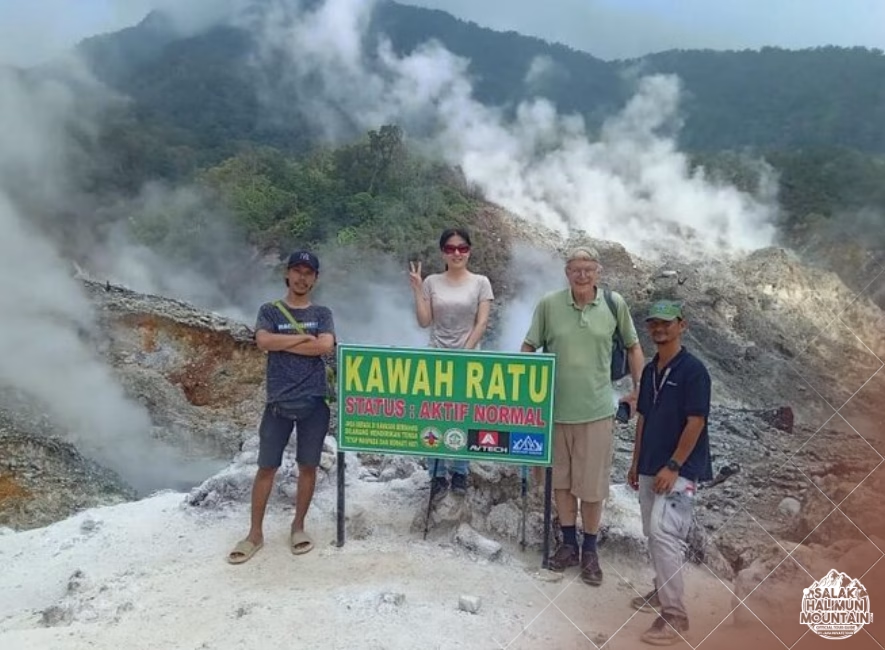
As this warm, humid air ascends into cooler high-altitude zones, it reaches its dew point and condenses rapidly into thick cumulus and stratus clouds. Near the summit crater (Kawah Ratu and Kawah Cikuluwung), this moisture mixes with thermal volcanic steam vents, creating dense, persistent sulfurous fogs that blanket the ridges for hours. Knowing that whiteouts are a natural, predictable part of the mountain’s daily weather cycle allows you to prepare mentally and logistically before setting out.
Distinguishing Ground Fog from Active Storm Fronts
Not all fog banks carry the same level of environmental risk. Static ground fog or localized cloud caps often bring high humidity, light drizzle, and reduced visibility, but relatively stable atmospheric pressure and low wind speeds.
Conversely, an incoming storm front brings rapidly dropping temperatures, gusting winds, and heavy downpours alongside thick fog. Paying attention to wind speed, temperature drops, and barometric pressure trends on your watch helps you evaluate whether to pause and wait for a fog bank to lift or immediately transition into cold-weather survival and descent protocols.
Tactical Navigation Protocols in Zero-Visibility Conditions
When visibility drops below ten meters, visual navigation changes fundamentally. You can no longer rely on looking ahead down the trail; instead, you must implement strict tactical movement protocols to ensure every step remains on the intended route.
The first rule of whiteout navigation is group consolidation. In dense fog, hikers separated by just fifteen or twenty paces can easily lose sight and sound of one another. Gather your trekking party immediately, assign a designated leader at the front and a sweep at the rear, and establish a mandatory maximum distance between group members—typically no more than two arm lengths apart. On exposed, narrow ridge trails, consider using a short guide line or keeping physical contact to prevent anyone from stepping off the trail edge.
Executing the Short-Leg “Leapfrog” Technique
If you must navigate across an open, featureless area—such as a rocky crater floor or an unshaped mountain saddle—without a visible trail in zero visibility, use the leapfrog technique.
The navigator stands at a fixed, confirmed point with a magnetic compass set to the desired bearing. The lead hiker walks forward into the fog along that exact bearing while the navigator watches them through the compass sighting mirror. Just before the lead hiker disappears into the mist, the navigator calls out for them to stop. The navigator then walks up to the lead hiker’s position, re-verifies the bearing, and repeats the process. This disciplined leapfrogging ensures your movement stays perfectly linear without veering off-course in circle patterns.
Leveraging Non-Visual Sensory Anchor Points
When fog eliminates long-range sight, your remaining senses become vital navigation instruments. Tuning into acoustic, tactile, and micro-climatic feedback allows you to maintain continuous awareness of your position relative to the mountain’s topography.
Sound behaves predictably in dense cloud cover. Heavy fog muffles high-frequency sound waves while allowing low-frequency sounds to bounce off steep canyon walls. Listen carefully for distinct acoustic anchors: the low, rhythmic roar of river channels in deep valleys below, the hiss of active fumaroles near crater zones, or the sound of wind whipping through high-altitude ridge pines. Keeping these acoustic reference points in mind helps confirm whether you are on a high ridge crest or descending into a protected drainage basin.
Micro-Climatic and Wind Direction Tracking
Wind direction provides an immediate, constant orientation vector when visibility vanishes. Before entering a cloud layer, note the direction of the prevailing wind relative to your trail (for example, a cold wind coming directly from your left shoulder as you ascend a north-facing spur).
As long as the broader weather system remains stable, that wind against your skin acts as a continuous directional check. If you suddenly feel the wind blowing against your back or face, your path has veered or you have inadvertently turned around. Pay equal attention to micro-climatic shifts: entering a cold, sheltered updraft often indicates you are stepping onto the lee side of a narrow ridge shoulder.
Integrating Compass, Altimeter, and Digital Tools
In zero-visibility conditions, your navigation tools are no longer secondary checks—they become your primary lifeline. Never rely on a single instrument; cross-referencing multiple tools provides absolute certainty when your eyes cannot confirm the path ahead.
Maintain continuous contact with your magnetic compass, using it to verify your walking heading every few steps rather than checking it sporadically. Pair your compass with a barometric altimeter. Because contour lines on a topographic map represent fixed elevation thresholds, knowing your exact altitude narrow down your possible location on a map to a single horizontal line, eliminating guess-work along steep mountain slopes.
Managing Satellite Navigation and Battery Conservation in Wet Mist
Digital GPS units and smartphone mapping applications are incredibly useful during whiteouts, providing real-time track logs and location overlays. However, cold, saturated fog banks can drain lithium batteries quickly and make touchscreens unresponsive to wet fingers.
Keep your electronic devices inside a waterproof pouch stored close to your body heat. Use your GPS primarily to verify your location coordinates and track line, while relying on your physical magnetic compass for real-time directional steering. Pre-download offline topographic maps and mark key trail waypoints—such as shelter points, water sources, and ridge junctions—before your trek begins so you can access crucial data without cellular service.
Volcanic Gas Safety in Salak’s Crater Fogs
Navigating fog banks near Mount Salak’s active volcanic zones—such as the Kawah Ratu crater complex—introduces a unique environmental hazard: toxic volcanic gas accumulation. Heavy fog and stagnant cloud layers trap heavier-than-air gases like sulfur dioxide ($SO_2$) and hydrogen sulfide ($H_2S$) close to the ground, particularly in low-lying depressions and enclosed gully floors.
When walking through whiteouts in crater areas, stay highly attentive to olfactory cues and respiratory comfort. A strong rotten-egg smell ($H_2S$) or a sharp, pungent throat irritation ($SO_2$) indicates elevated gas concentrations. If you encounter dense sulfurous steam or feel eye or throat discomfort, do not attempt to push forward through low-lying steam corridors. Immediately put on a protective mask or damp cloth over your nose and mouth, turn around, and ascend to higher, wind-ventilated ridge ground out of the gas trap zone.
Patience, Decision-Making, and Turning Back Protocols
The most important skill when navigating Salak whiteouts is knowing when to pause. Pushing forward blindly through dangerous terrain—such as the narrow, knife-edge ridges leading toward Salak’s main peaks—in total zero visibility increases the risk of serious accidents unnecessarily.
If fog density makes trail identification impossible or if your group shows signs of fatigue and panic, stop at the nearest secure, level terrain feature away from cliff edges and falling limb hazards. Put on warm insulation layers, pull out waterproof rain gear, and wait thirty to forty-five minutes. Tropical fog banks on West Java’s peaks are dynamic; shifting mountain winds often create sudden, brief visibility windows that allow you to confirm your route and move forward safely.
Mastering whiteout navigation transforms a potentially stressful environmental challenge into a controlled, confident wilderness experience. By keeping your group tight, applying disciplined compass technique, reading micro-climatic cues, and respecting the volcanic terrain, you can navigate Mount Salak’s atmospheric cloud zones with skill, safety, and deep peace of mind.
So, if you’re ready to explore the wonders of Mount Salak Halimun, head over to our ONLINE BOOKING PAGE and let’s start planning your adventure. Or simply CLICK THIS LINK to chat with us on WhatsApp.
With our team, you’re not just getting a guide; you’re gaining a local friend who will ensure your trip is nothing short of extraordinary.